
What Is a Contour Survey?
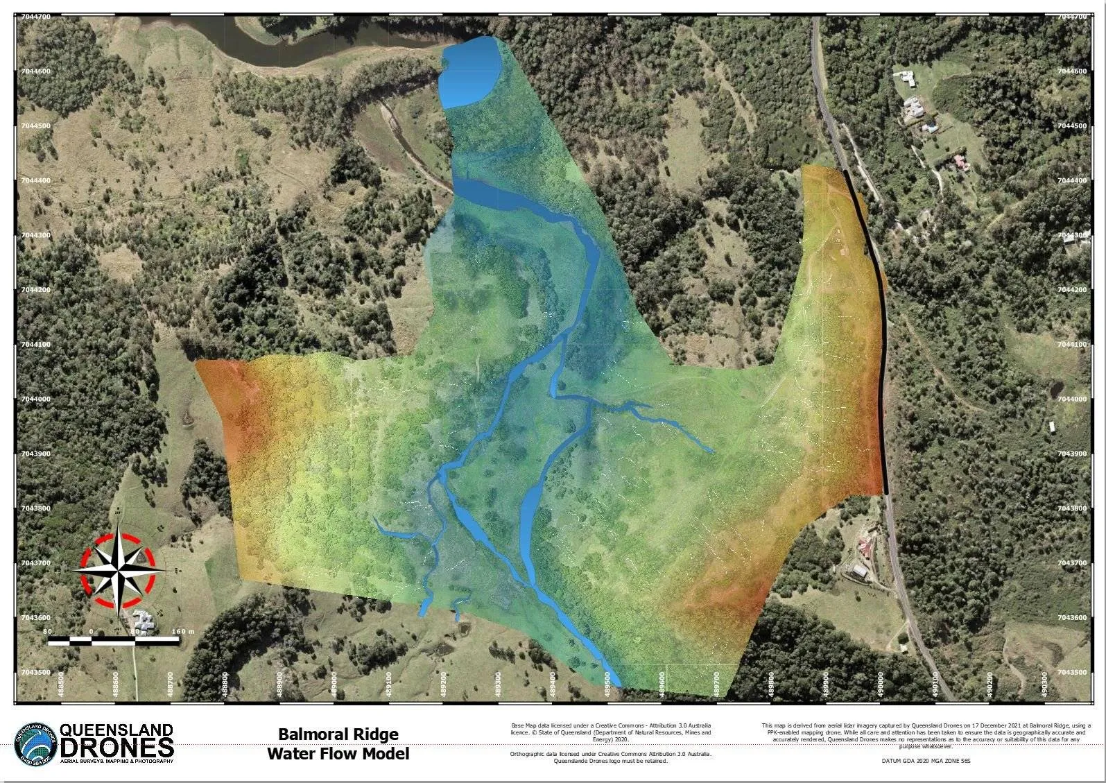
In this article, Queensland Drones Chief Remote Pilot, Tony Gilbert, shares his learnings from more than 10 years of topographic mapping and helping clients with elevation contour surveys
Last Updated 30 August 2026
A contour survey is a way to easily visually understand the vertical and horizontal shape (the “topography”) of your land. By understanding the land contours, you can easily visualise or map how water will flow over the property when it rains, where it will collect, where it might erode the soil and many other important water flow characteristics, where to build access roads and how to farm your property along the contours. From this simple base, you can even develop water flow models, stream maps and determine the best places to create dams and silt traps.
Do contour surveys need to be conducted by a registered surveyor?
No not alt all. A registered surveyor is required if the contour survey data is being used for construction or engineering purposes, or if the boundary data is being registered on a government cadastral (land title) system. Otherwise, surveyor certification is generally not required. We partner with a registered surveyor (yours or ours) where certification is required, but generally an unregistered survey is more than sufficient for a contour survey.
Are contour surveys by a registered surveyor more accurate than drone surveys?
They can be. In theory, a surveyor’s measurement system can achieve accuracy 5mm, but in reality the average accuracy used by surveyors on ground surveys is around 10-15mm, which is very similar to the accuracy achieved by a well-designed drone survey. Ground surveys typically measure around 5-6 points per square metre or less. Aerial surveys can measure 100s of points per square metre. You do the math! For the best combination of accuracy and cost-effectiveness, you should combine an aerial LIDAR survey with ground control points measured by a surveyor.
Is a registered surveyor faster and cheaper than a drone survey?
Not at all! The area that a ground survey team can cover in a day can be covered by an aerial survey in 1-2 hours. The area a ground surveyor would take a week to complete can be done with a drone survey in a day. Both methods have similar processing times, although drone survey results are usually ready in a few days, while ground survey data can take weeks to process and deliver. Aerial LIDAR mapping is a way of leveraging the skills of a traditional surveyor, not necessarily replacing them.
Can precise aerial land mapping only be achieved using LIDAR?
Well, no, not really. Queensland Drones uses both LIDAR and photogrammetric aerial survey techniques and generally speaking any terrain with less than 50% tree cover can probably be mapped using a photogrammetric drone mapping camera with a reasonable degree of accuracy, but LIDAR will always give a better result.
Drone mapping relies on making connections (extrapolation) between visible ground points, just as a traditional ground survey does. Where there are doubts about accuracy due to long grass or thick vegetation, LIDAR mapping will generally deliver a better result as it can, to some extent, “see” below the vegetation to the underlying ground levels. This is because it’s using 100s of reflected light pulses every second, often spread in a field of view more than 70 degrees wide. If a point on the ground can’t be detected on one pass, it will almost certainly be detected on the next pass which is firing the laser pulses in the opposite direction.
Please feel free to chat with us about this if you have concerns. Call us on 1300 246 977, email in**@***********om.au or complete the Online Enquiry Form so we can discuss your requirements.
Why are contour surveys are so important?
Elevation data is essential for planning your home or any building construction projects, and following the contours of the land is the cheapest way to build roads and tracks through your property. For many types of agriculture, especially tree crops (like mangoes, macadamias, avocados, etc), planting along the contours of the land is the best strategy for maximum yield.
In construction projects, contour mapping is an essential tool to first understand the structure of the site, then calculate how much soil and other material needs to be added or removed to make the structure of the site fit the construction plan, and then to understand and verify how the terraforming of the land fits with the engineering design.
How do you read a contour survey?
In the most basic terms, a contour survey illustrates the elevation differences across your land, in regular intervals, from the lowest point to the highest point. Contour lines join points at the same elevation. The closer together the contour lines are, the steeper the section. The further apart the lines are, the shallower the rise or fall of the terrain.
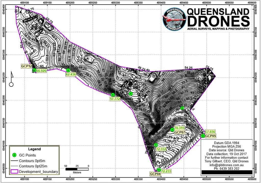
This contour and elevation map shows topographic data at intervals down to 0.25m (25cm), but we can calculate accurate contours down to 10 cm on lightly undulating land.
Contour surveying is best illustrated using the image above, which shows the structure of an excavation across a narrow valley with a ridge at each end and a gully in the middle. The gully features a small dam and a marshy wetland around the dam. The tight contours on right side show a steeply rising hill which flattens out in the south-east corner, where a construction site office has been located. To the west of centre we can see that the directions of the slope change and the land again rises to a small plateau. The numbers on the sides represent the “MGA” coordinates. You might be used to latitudes and longitudes, but MGA coordinates are more useful in maps of this kind as they allow direct measurement in metres from point to point. Each MGA pair corresponds to a latitude and longitude and are easily converted using online calculators.
How do you get a contour survey?
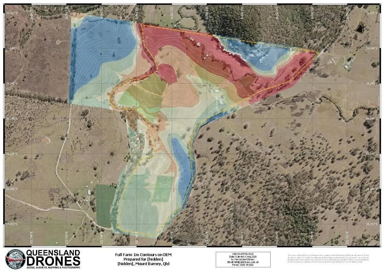
Traditionally, topographical land surveys mean engaging a surveyor who sends a team of people to the site with survey poles and tripods and spend days, or even weeks, walking around every part of the site to measure points of different elevation. You would then wait weeks to see a large map of the site with all the survey results on it.
In the world of aerial topographic mapping using drones, this kind of mapping can be done in a matter of hours, or perhaps a day or two, using precision PPK-equipped mapping drones which can cover up to 1000 acres of land per hour and still achieve real world precision of 2-3 cm in most cases, equivalent to that delivered by a traditional surveyor but with many more survey points and high-resolution mapping imagery to make the contours easier to comprehend.
An aerial contour mapping survey can identify many features traditional surveying might overlook, like hidden gullies and streams, natural watercourses, old abandoned tracks and areas that could be inaccessible entirely to a surveyor on foot.
What’s the difference between Photogrammetry and LIDAR in contour surveys?
We cover this in great detail in our article “9 Key Differences Between Photogrammetry and LIDAR“, which is available free on our website.
How much does a Contour Survey cost?
We cover the cost of both photogrammetry and LIDAR surveys in detail in our article “How Much Does LIDAR Mapping cost“.
To find out more about getting an aerial contour survey for your property or project, complete our simple aerial mapping enquiry form or phone Tony on 1300 246 977 for a chat about your project. Yes, you can actually chat to the Chief Remote Pilot, not a receptionist or marketing lackey! How refreshing!
Leave a Reply
You must be logged in to post a comment.

2 Comments