Aerial LIDAR Mapping and Surveys
Colourised Point Clouds, Detailed Surface Models, Breaklines and Features
Queensland Drones delivers precise, high quality Aerial LIDAR Mapping on-demand for 3D visualisation, digital twin creation, vegetation mapping, feature mapping, contour mapping, volumetric analysis and more. We work primarily with engineers, surveyors and property developers to deliver CAD- and BIM-ready data including breakline-constrained TiN Mesh, 3D point clouds, drainage models, flood risk models and vegetation models.
Enquire now about our LIDAR Mapping Services…
How Accurate is LIDAR Mapping?
Our PPK-enabled airborne LIDAR mapping sensor with fully integrated and calibrated 26MP RGB mapping camera delivers LIDAR mapping accuracy of 5-10cm without ground control points and 2-4cm precision when combined with accurately measured ground control points.
Use Cases for Aerial LIDAR Mapping
Our UAV LIDAR mapping and aerial LIDAR survey services are designed for:
- 3D modelling of buildings and developments
- Topographic mapping of land and properties
- 3D and volumetric mapping for mines and quarries
- Vegetation mapping for environmental management and agronomy
- Tree counts and tree metrics for forestry and orchards
- Precise elevation, contour and survey mapping
- Levelling, excavation and cut-fill calculations
- Archaeology and cultural heritage management
- Highway construction and corridor mapping
- Powerline mapping and vegetation modelling
Enquire now about our Aerial Lidar Mapping Services
Aerial LIDAR Mapping Deliverables
We provide a full LIDAR point cloud and RGB orthomosaic data processing service delivering BIM/CAD ready outputs including:
- 3D fully colourised point cloud (LAS, LAZ or XYZ format)
- ASPRS-classified point cloud (full or thinned to your specification)
- Point Cloud classified to ground, buildings, powerlines, vegetation, etc.
- Planimetric feature identification (vector mapping of structures and infrastructure)
- Digital Elevation Model (DEM – actual ground and ground-based structures)
- Digital Terrain Model (DTM/DSM bare earth model)
- Precise Elevation Contours (DWG, SHP or other formats)
- 2D high resolution orthographic imagery (GeoTIF or ECW format)
- Terrain profiling (elevations across slices of terrain)
- Water pooling projections (flood risk mapping, water storage planning)
- Volumetric calculations (cut and fill, stockpile, change measurement)
- Accurate height calculation of above ground objects
How Do You Access LIDAR Maps?
Once the colourised LIDAR mapping data and RGB photos have been transformed into precise aerial mapping deliverables, you can access them in a number of ways:
- Download from our Secure Client Portal – a cloud-based delivery system
- On a USB Drive – we can post the deliverables to your office
- On a Secure Presentation Platform – you can browse all kinds of mapping outputs on the internet
We suggest that you discuss your output requirements and how you plan to use them with our consultant before ordering your aerial LIDAR mapping survey, so we both know what to expect.
The Process of Drone LIDAR Mapping
Our aerial LIDAR mapping is not reliant on flight schedules or complicated setups. Our qualified and experienced UAV pilots can be on-site usually within a matter of days to capture the data you require.
Most of our drone LIDAR mapping data processing is done in-house, so you don’t need to wait weeks to see the results either.
We can deliver the outputs of our service in formats you can load into your own BIM, CAD or other GIS mapping systems, or we can host your data in our own Global Cloud Server for you to access and share with others as required.
Enquire now about our Lidar Mapping Deliverables
Drone LIDAR Mapping for Surveyors and Engineers
As a commercial drone service provider who has specialised in aerial photogrammetry (mapping the ground using stereographic photos captured from a drone) for more than six years, we’ve refined and fine tuned our process to achieve accurate ground surface mapping across all kinds of terrain.
But sometimes aerial photogrammetry is just not enough. If the surface to be mapped is covered by heavy tree canopies or vegetation – even crops or long grasses – finding the true ground elevation can be very challenging. That’s why Queensland Drones also offers precision drone LIDAR mapping where required to achieve the outcomes our customers expect.
We regularly working hand in hand with traditional surveyors and engineering companies to bring the power of drone LIDAR mapping to conventional survey methods as a way to leverage the skills and methodologies of traditional surveyors.
Bringing together the traditional survey methods used by registered surveyors, especially using RTK ground measurements and Total Station, produces something extremely powerful and cost-effective that has not existed previously.
A three man traditional survey team equipped with RTK ground rovers and a Total Station can typically collect around 100 precise data points per hour in good terrain conditions. Typically the survey is going to cut across a number of assets like roads, footpaths, rail lines, drains, underground infrastructure, etc, that need to be integrated into the survey and considered in any planned design changes. So do you spend days or weeks doing traditional surveys to ensure everything has been captured? Or do you leverage UAV LIDAR mapping technology to make it all happen in a day or two?
For our UAV LIDAR mapping case study we’re looking at a site where one part has already been surveyed but the works planned are the next stage of the development, including footpath and service extensions. There is a busy road running through the site which would present a risk for surveyors taking ground measurements along the road. There’s a busy railway line and a couple of construction base camps that need to be considered. A traditional survey would require 3-4 days work just to get accurate levels along the road.
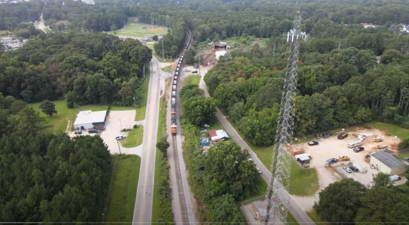
The UAV LIDAR-assisted workflow combines some traditional precision survey ground control points along the edges of the road and out into the hard surface areas nearby, with high density LIDAR data collected over 3-4 hours using an enterprise RTK-enabled drone. The plan is to duplicate the existing surveyed area and overlap into the proposed development area so we can easily check and validate the accuracy of the LIDAR data captured by the drone. Not only will this method allow us to capture the road and adjacent surfaces, but also a lot of other terrain that we could never capture in a 3-5 day survey timeframe using conventional methods.
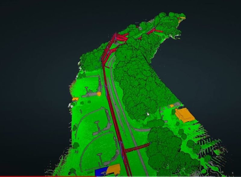
The data collected from the enterprise drone LIDAR Mapping platform is processed into a dense point cloud which can then be analysed and interrogated to extract the essential data required for the survey. What’s interesting to consider here is that where a traditional survey team might collect 100-200 data points over 3-4 days on site, our UAV LIDAR platform has collected around 450,000 data points in just 3-4 hours. But we’re not interested in a pretty picture, we need to see data which can be validated using conventional survey methods.
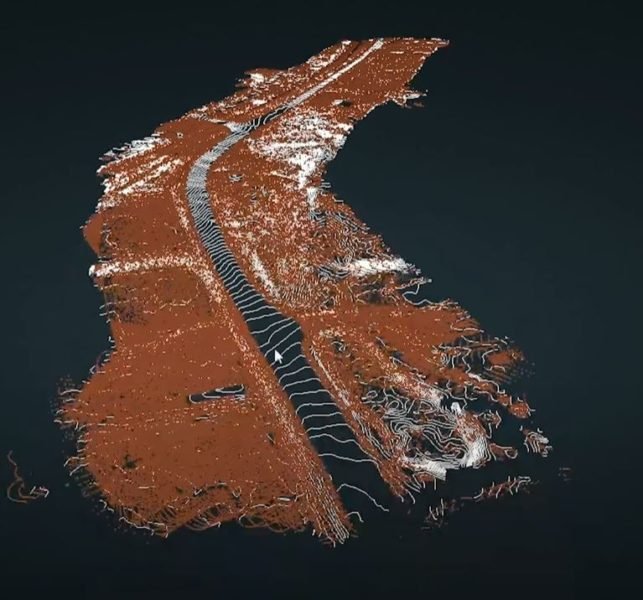
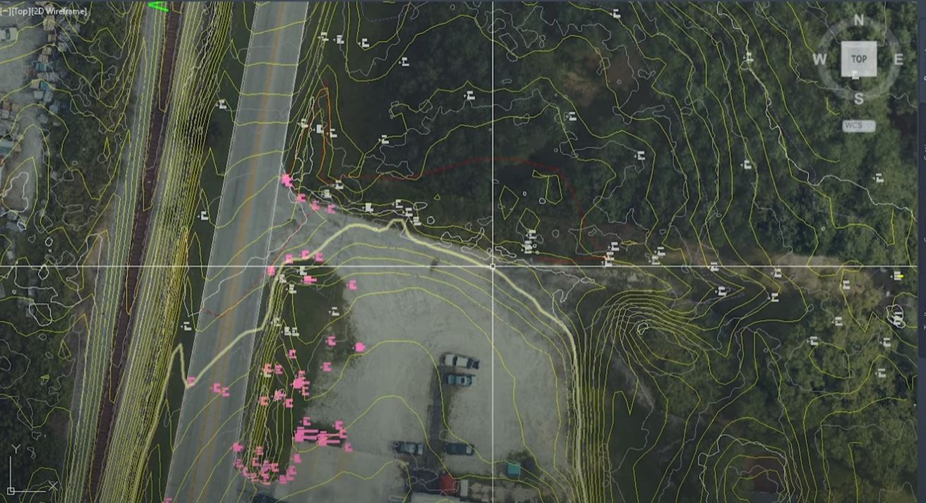
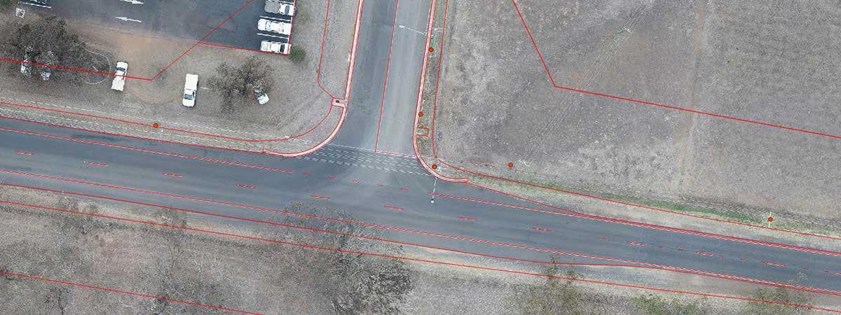
When we remove all of the points above the ground surface, we’re left with a detailed Digital Terrain Model (DTM) which can be overlaid with precise elevation contours. Along the hard surfaces like the road and the existing footpath, we can use traditional surveyed ground controls to validate the accuracy and reliability of the LIDAR data across the entire site.
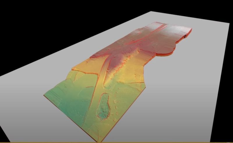
The next step is to import the ground classified DTM into a more conventional survey analysis tool like Virtual Surveyor, where traditional survey techniques can be applied to create breaklines and other deliverables from the LIDAR point cloud data.
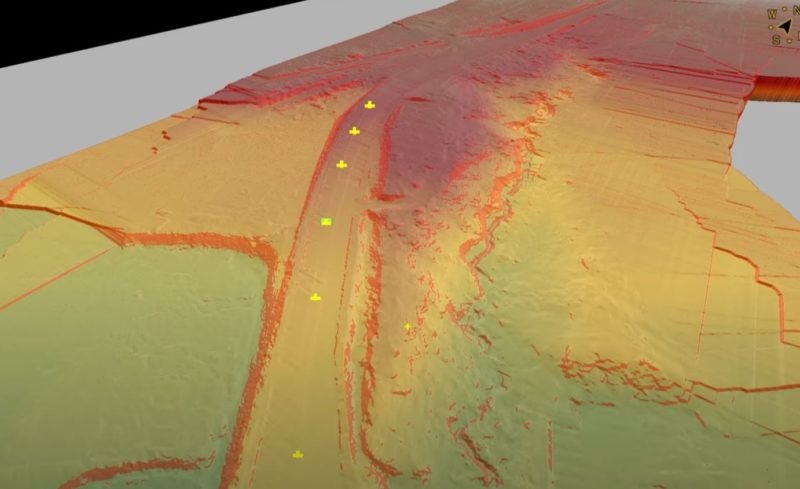
Once the DTM has been imported into Virtual Surveyor, the many points that currently make up the breakline surfaces in the LIDAR point cloud can be rationalised using traditional survey processing techniques. At this point there is almost too much data to work with, which is a pleasant change, but we don’t need to use all of it. Just the parts that inform useful interpretations of the data.
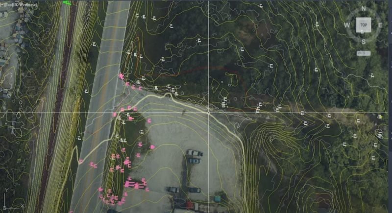
No voodoo here. Once we have the breaklines established in a packaged like Virtual Surveyor, we can bring all the data across the Civil 3D or another CAD package and check the LIDAR point positions and levels against both the ground control points created using traditional survey techniques and the previous elevations and locations from the first stage design data.
Extending the reach of your traditional survey teams using UAV LIDAR Mapping should not mean any loss of accuracy of fidelity in the overall survey data. In fact, it should extend the fidelity of your ground survey to a much larger area, with much greater levels of information.
Our air crew and ground crew can work on-site with your survey team, or independently as preferred.
Give Tony a call on 1300 025 111 to discuss your survey requirements, or complete the enquiry form below and we’ll get back to you to discuss options.
Find Out More About UAV LIDAR Mapping For Your Project
Interested in what it costs to have an Aerial LIDAR Mapping Survey? Check this out:
We hope to add more case studies in the near future, so please check back regularly for updates.
Aerial Lidar Mapping Enquiry
[wpforms id=”12468″]
